-
Humanitaarteaduste ja kunstide valdkondHumanitaarteaduste ja kunstide valdkonna dekanaatJakobi 2, r 116-121 51005 Tartu linn, Tartu linn, Tartumaa EST0Ajaloo ja arheoloogia instituutJakobi 2 51005 Tartu linn, Tartu linn, Tartumaa EST0Eesti ja üldkeeleteaduse instituutJakobi 2, IV korrus 51005 Tartu linn, Tartu linn, Tartumaa EST0Filosoofia ja semiootika instituutJakobi 2, III korrus, ruumid 302-337 51005 Tartu linn, Tartu linn, Tartumaa EST0Kultuuriteaduste instituutÜlikooli 16 51003 Tartu linn, Tartu linn, Tartumaa EST0Maailma keelte ja kultuuride instituutLossi 3 51003 Tartu linn, Tartu linn, Tartumaa EST0UsuteaduskondÜlikooli 18 50090 Tartu linn, Tartu linn, Tartumaa EST0Viljandi kultuuriakadeemiaPosti 1 71004 Viljandi linn, Viljandimaa EST0Humanitaarteaduste ja kunstide valdkonna emeriitprofessorid0Humanitaarteaduste ja kunstide valdkonna emeriitdotsendid0Sotsiaalteaduste valdkondSotsiaalteaduste valdkonna dekanaatLossi 36 51003 Tartu linn, Tartu linn, Tartumaa EST0Haridusteaduste instituutJakobi 5 51005 Tartu linn, Tartu linn, Tartumaa EST0Johan Skytte poliitikauuringute instituutLossi 36, ruum 301 51003 Tartu linn, Tartu linn, Tartumaa EST0MajandusteaduskondNarva mnt 18 51009 Tartu linn, Tartu linn, Tartumaa EST0Psühholoogia instituutNäituse 2 50409 Tartu linn, Tartu linn, Tartumaa EST0ÕigusteaduskondNäituse 20 - 324 50409 Tartu linn, Tartu linn, Tartumaa EST0Ühiskonnateaduste instituutLossi 36 51003 Tartu linn, Tartu linn, Tartumaa EST0Narva kolledžRaekoja plats 2 20307 Narva linn, Ida-Virumaa EST0Pärnu kolledžRingi 35 80012 Pärnu linn, Pärnu linn, Pärnumaa EST0Sotsiaalteaduste valdkonna emeriitprofessorid0Sotsiaalteaduste valdkonna emeriitdotsendid0Meditsiiniteaduste valdkondMeditsiiniteaduste valdkonna dekanaatRavila 19 50411 Tartu linn, Tartu linn, Tartumaa ESTBio- ja siirdemeditsiini instituutBiomeedikum, Ravila 19 50411 Tartu linn, Tartu linn, Tartumaa ESTFarmaatsia instituutNooruse 1 50411 Tartu linn, Tartu linn, Tartumaa ESTHambaarstiteaduse instituutL. Puusepa 1a 50406 Tartu linn, Tartu linn, Tartumaa ESTKliinilise meditsiini instituutL. Puusepa 8 50406 Tartu linn, Tartu linn, Tartumaa ESTPeremeditsiini ja rahvatervishoiu instituutRavila 19 50411 Tartu linn, Tartu linn, Tartumaa ESTSporditeaduste ja füsioteraapia instituutUjula 4 51008 Tartu linn, Tartu linn, Tartumaa ESTMeditsiiniteaduste valdkonna emeriitprofessorid0Meditsiiniteaduste valdkonna emeriitdotsendid0Loodus- ja täppisteaduste valdkondLoodus- ja täppisteaduste valdkonna dekanaatVanemuise 46 - 208 51003 Tartu linn, Tartu linn, Tartumaa ESTArvutiteaduse instituutNarva mnt 18 51009 Tartu linn, Tartu linn, Tartumaa ESTGenoomika instituutRiia 23b/2 51010 Tartu linn, Tartu linn, Tartumaa ESTEesti mereinstituutMäealuse 14 12618 Tallinn, Harjumaa EST0Füüsika instituutKeemia instituutRavila 14a 50411 Tartu linn, Tartu linn, Tartumaa EST0Matemaatika ja statistika instituutNarva mnt 18 51009 Tartu linn, Tartu linn, Tartumaa EST0Molekulaar- ja rakubioloogia instituutRiia 23, 23b - 134 51010 Tartu linn, Tartu linn, Tartumaa ESTTartu observatooriumObservatooriumi 1 61602 Tõravere alevik, Nõo vald, Tartumaa EST0TehnoloogiainstituutNooruse 1 50411 Tartu linn, Tartu linn, Tartumaa ESTÖkoloogia ja maateaduste instituutJ. Liivi tn 2 50409 Tartu linn, Tartu linn, Tartumaa ESTLoodus- ja täppisteaduste valdkonna emeriitprofessorid0Loodus- ja täppisteaduste valdkonna emeriitdotsendid0Bioinseneeria instituutNooruse 1 50411 Tartu linn, Tartu linn, Tartumaa ESTAkadeemilise sekretäri tegevusvaldkondPersonaliosakondUppsala 6, Lossi 36 51003 Tartu linn, Tartu linn, Tartumaa EST0Finantsjuhi tegevusvaldkondRahandusosakondJakobi 4 51005 Tartu linn, Tartu linn, Tartumaa EST0Kantsleri tegevusvaldkondInfotehnoloogia osakondUppsala 10 51003 Tartu linn, Tartu linn, Tartumaa EST0KantseleiÜlikooli 17 (III korrus) 51005 Tartu linn, Tartu linn, Tartumaa EST0Kinnisvaraosakond0Turundus- ja kommunikatsiooniosakondÜlikooli 18, ruumid 102, 104, 209, 210 50090 Tartu linn, Tartu linn, Tartumaa EST0Rektori tegevusvaldkondRektoraadi bürooÜlikooli 18 50090 Tartu linn, Tartu linn, Tartumaa ESTSiseauditi bürooÕppeprorektori tegevusvaldkondÕppeosakondTeaduskoolUppsala 10 51003 Tartu linn, Tartu linn, Tartumaa EST0Üliõpilaskonna bürooÜlikooli 18b 51005 Tartu linn, Tartu linn, Tartumaa EST0Õppimis- ja õpetamiskeskusLossi 36-401 51003 Tartu linn, Tartu linn, Tartumaa ESTTeadusprorektori tegevusvaldkondTartu Ülikooli raamatukoguW. Struve 1 50091 Tartu linn, Tartu linn, Tartumaa EST0GrandikeskusRaekoja plats 9, III korrus 51004 Tartu linn, Tartu linn, Tartumaa ESTArendusprorektori tegevusvaldkondEttevõtlus- ja innovatsioonikeskusNarva mnt 18 51009 Tartu linn, Tartu linn, Tartumaa EST0Loodusmuuseum ja botaanikaaedVanemuise 46 51003 Tartu linn, Tartu linn, Tartumaa EST0Rahvusvahelise koostöö ja protokolli osakond0MuuseumLossi 25 51003 Tartu linn, Tartu linn, Tartumaa EST0

Catherine Helen Gibson: What Can Maps Tell Us About the History of Religion?
Our new Research Fellow in Church History, Catherine Helen Gibson (PhD) talks about her research – she investigates the extent to which religion was a central factor in imperial life and politics in the Baltic provinces in the 19th century.
Although Estonia is today widely recognised as a very secular country, my research investigates the extent to which religion was a central factor in imperial life and politics in the multireligious environment of the Baltic provinces in the 19th century. My current project aims to address the following questions: To what extent did religion function as a meaningful form of identification in Estland, Livland, and Kurland during a period when ideas about nationhood and nationality were becoming more prevalent in public discourse? In what ways did religion cut across national and linguistic communities and function as an alternative way of structuring social groups and perceptions of space?
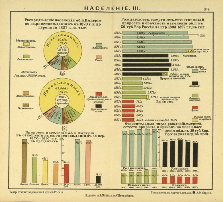
My research uses a history of science approach to examine the collection, management, and mapping of statistical data on confessional issues. I am especially interested in how different techniques of data visualisation – such as maps and diagrams – began to be used in the 19th century to analyse and communicate information about religious matters. As we are reminded by contemporary discussions around GIS (Geographic Information Systems), maps are not neutral representations of reality. They are objects made by people and consequently reflect the attitudes and motivations of the mapmaker.


By analysing maps and data visualisations as historical sources, I explore how confessional statistics and mapping emerged in the second half of the 19th century as objects of debate and polemic. Imperial bureaucrats, religious and educational administrators, and scholars all engaged with statistics and mapping to promote different visions of the region’s religious landscape. These different actors experimented with different graphical techniques, colours, and symbols to influence how people saw and thought about religious issues.
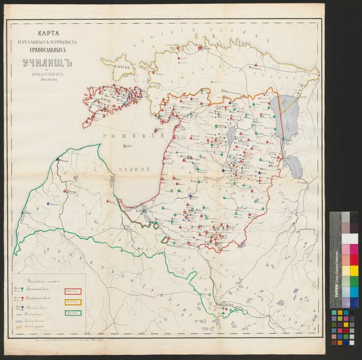
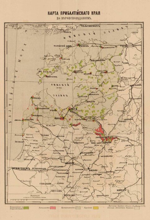
A clear example of the way in which statistical maps of religion became politicised is a Russian-language map produced in 1873 of religious communities in Estland, Livland, and Kurland provinces. The map was compiled by cartographer Aleksandr Rittikh (1831-1914?) and the project was supported by a generous grant from Imperial Geographical Society in St. Petersburg. By shading the Orthodox population in bright green, the map highlighted the impact of the mass conversion in the 1840s of around 100,000 peasants in Livland from Lutheranism to Orthodoxy. Although the majority of the region’s population were Lutheran, they were depicted in a very light shade of green and are hardly visible on the map. Rittikh’s map also did not count Old Believers as a separate religious group, but classified them together with the Orthodox population. Rittikh used cartography to make a statement about the strength of Orthodox life in the Baltic, emphasise strong cultural ties with Russia, and legitimise imperial rule in the region. The map also marked places inhabited by Roman Catholics and Jews (depicted in red and yellow, respectively), both of which were considered to be troublesome populations in the eyes of conservative Russophiles such as Rittikh.

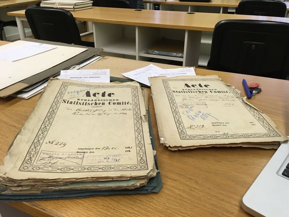
My research involves analysing published materials as well as sources and manuscripts located in archives in Tartu and Riga. I am also planning at trip to Russia later in the year to examine materials in St. Petersburg.

Thank you to everyone in the School of Theology & Religious Studies for their warm welcome to the department and please get in touch if you would like to talk more about history of religion in the Baltic region and Russian Empire.
My project, “Seeing Through Numbers: Counting and Mapping Religious Communities in the Baltic Provinces, 1840-1914”, runs from September 2019 to August 2021. The research is supported by the European Regional Development Fund and the programme Mobilitas Pluss (Grant No. MOBJD517). Additionally, archival trips are supported by an Emerging Scholars Research Grant from the Association for the Advancement of Baltic Studies.
Some of my recent articles on this topic include:
Gibson, Catherine (2020). Mapmaking in the home and printing house: women and cartography in late imperial Russia. Journal of Historical Geography. https://doi.org/10.1016/j.jhg.2019.10.011
Gibson, Catherine (2018). Shading, lines, colors: mapping ethnographic taxonomies of European Russia. Nationalities Papers: The Journal of Nationalism and Ethnicity, 46 (4), 592−611. https://doi.org/10.1080/00905992.2017.1364229
February 11, 2020


